Thursday, July 28, 2011

Tahoe, Rides 1-3

In order to save time (I'm lazy) and to make a long story short (rarity for me), I am throwing all three rides into one entry.
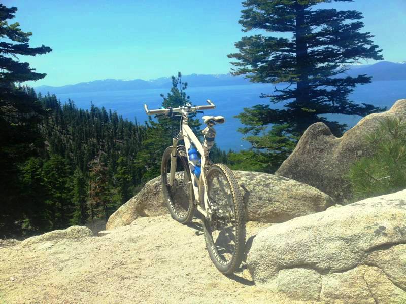
This pic does not do the view from the deck justice.  We could see a lot of the lake, with sail boats, para-sailing etc.  Beautiful!

Riding in Tahoe was AMAZING!  Though I have been to Tahoe many times, I have never ridden a mountain bike there; boy was I missing out.  From where I was staying (Dollar Point) I had access to a maze (literally) of trails.  My first ride started at ~6350' elevation.  I was lucky enough to meet a group just getting started at a trail-head at the Nordic Ski Center, and followed them up to what is called the 'Fiber Board Freeway' (old paved logging road) and then further up and onto the Tahoe Rim Trail and then up a bit further before a nice, but technical downhill.  After 18 miles, we were back to the start, so I set off on my own and re-rode most of the route just so I could remember it for another ride.  The group rode slow enough that the elevation was not really a factor (only felt it while climbing), and I ended my ride by jumping into the most beautiful lake in the U.S..  Total miles ~30.

The next ride I took the same route from Dollar Point up to the Fiber Board Freeway and then to the Tahoe Rim Trail.  From there I made the poor decision to ride the TRT up to Watson Lake.  I was told the trail was not SS friendly, and it certainly was not.  A lot of technical climbing with a lot of slow, sandy trail.  Still, I pushed on (literally) and made it to the lake and back.  Total ride was only 25 miles, but much tougher than the ride two days earlier.
Still some snow on them there trails.  You almost can't see my dirty white bike as it blends in with the dirty white snow.  Interestingly, a yellow patch of snow emerged shortly after taking this picture.
 For my last ride, I did the ride that everyone should do if they have a mountain bike in Tahoe, the Flume Trial.  To add more miles, and to make it more challenging (much more challenging than I thought), I started at Mt. Rose Summit about 3/4 up from the Tahoe Meadows trail head at 8900'elevation.  From there I bombed down Tahoe Meadows to the Flume Trail and rode the scenic trail to Marlette Lake; rode around the lake, then headed back.  It was all good until that dreaded, "What goes down, must go up" mtb rule came into play.  I was grinning ear to ear flying down the Tahoe Meadows trail...now I was grimacing ear to ear riding back up.  I realized too late that I spent so much time enjoying the scenery, that I did not eat enough calories (or drink enough water) to account for the extra elevation, and I was starting to bonk.  That coupled with many uphill areas with deep sand, made for a miserable climb.  Here I was on a 26" single-speed, on Racing Ralphs, with tubes.  I was wishing I was on a geared 29er with some beefy tubeless tires.  So I walked several sections, ate a bar and some jerky, and drank some water.  I also learned that though the temp. was in the 70's. being at that elevation, and in full sun the entire time, really takes it's toll on you, or at least me).  The ride ended up being ~33 miles of just amazing trails.  The pics do not do justice to the beauty of the landscape, but if have been there, then you know.  Looking forward to a return visit with more appropriate gear.  Great, great time.
Nice view off the Tahoe Meadows Trail, almost to the Flume Trail.

A rider I met at the trail-head was kind enough to stop and take this pic on my return.

 
Tried to take a cool pic...ended up dropping the bike on my shoulder and rode back sore, with a large dirty grease stain on my left shoulder. :(   That'll learn me!
Rode partially around Marlette Lake until some guys warned me the trail I was about to hit was not SS friendly.  They were pretty convincing, so I headed back to the picturesque Flume Trail.
The Flume Trail signage as I return from Marlette Lake.  Seemed to be a popular resting spot for many.

The Carson Valley on the opposite side of the ridge from Tahoe.


That cool water is looking pretty good right about now.

Relaxing with my thoughts...unfortunately, I don't have many thoughts, so it was a short break.

Riding away.

Because one shot of my arse is not enough, here is a close-up for you sick'os.
You though Bin-Laden was dead?  You are wrong Infidels!  He is alive and well sporting a freshly shaved head and shredding the trails at Tahoe's highest summit!

The best way to end a ride in Tahoe?  Duh, head straight to the beach and join the family for a swim.  Ahhh, so refreshing.  Good Times!

Thursday, July 21, 2011

Auburn Ride #4 & 5

Ride #4
For this ride, I thought I would try ride #3 again.  I had fun bombing 3.5 miles down to the Confluence where many trails start, and saw a group getting ready for a ride.  Four guys, three in kits looking like they should be in the Tour D' France.  I struck up a conversation and they were cool about me joining them, but as always, I was immediately intimidated by the cool matching kits and shaved legs.  Fortunately, one guy was not wearing a kit, and I was glad to see the hair on his legs...I thought, maybe I had a chance to stay with this guy.   As soon as they started, I was in trouble.  The ride started with a mile of flat, sometimes technical trail on a ridge and they quickly left me behind.  When we hit the climb ~2.5 miles of up, up, up, I started gaining on them but quickly realized that I no longer had the 'Contador Bounce' as I was climbing and thus had to really gut it out.  I eventually caught two of them.  One of the riders, the only one on a SS (GF Rig), turned and said (in a surprised tone), "Hey, your still here?!?".  I told them I would hang on as long as I could, but not to worry about dropping me.  I continued my pace, and like true roadies, they were  not going to let me pass, so we  eventually caught the first two guys.  They stopped at the top of the climb, seemingly un-winded, to chat.  This allowed me some time to recover before hitting some rolling single track (Connector Trail).  Once again they quickly dropped me on the single track, but halfway though, I passed two of them like they were standing still...because they were standing still.  One guy had flatted which gave me the opportunity to catch the group and then rest at the end of the trail (4 miles).  Still, despite riding hard, I was struggling.  My legs are not use to so much riding, climbing and full sun.  Unlike NC trails which are mostly shaded, there is little escape from the sun.  In spite of dry heat (no real humidity), 90+ degree temps in full sun wears on you.  I decided to let these burners go and do a different ride.  I rode back to the Confluence, hit the relatively easy/moderate Quarry trail (follows the river) for an out-and-back, and then up Stagecoach and home (3.5 miles up).  Still a good ride with over 30 miles.  Interestingly, I felt great going up Stagecoach which made me think I was a chump for not trying to stick with 'The Kits's.  I could have kept catching them on the climbs (or when they flatted) and maybe stayed with them the enter ride.  I am bummed for not pushing myself harder, but I was having a tough time gauging my fitness knowing I had a long climb to finish the ride.
Cest' la Vie.
Back down, down, down Stagecoach...

under the bridge on the Clementine trail...
climb up, up, up, to the connector trail to the Forest Hill Divide Loop Trail...
fly though this on the bombin' downhill...


noticed an old quarry with a cool looking cave (look carefully) just off the trail...
hit the bottom of the trail and rode across the confluence and up hwy 49...


and hit the Quarry Trail which was thankfully flat for a stretch.

Rode up a steep incline to part of the old quarry area (and met some nice hikers)...

and then rode down to the cave.
Rode a ways past the cave before turning around (Quarry Trail is an out and back trail)


And then began the long climb up Stagecoach...
  
 
Up, up, up to the start (at the In-laws house).

 Ride #4
Same as Ride #1.  Snuck out early and was in constant fear of getting attacked by a mountain lion or bear (both have been seen in the area in the early morning)...but somehow survived.  Now a week off before hitting the trails at Tahoe Baby!!!

Sunday, July 10, 2011

Auburn Ride #2 & 3

Ride #2, Salmon Falls
For my second Auburn, CA ride, I met my old friends/former riding partners Paul S. and Cameron B. for the 'newer' Salmon Falls trail (for the record, they are in their 30's).  This trail starts with a series of steep switchbacks that take you up, up, up to a long up and down section of double track that again turns into sweet single-track. We followed this fairly fast, flowy trail (with Paul setting a blistering pace) through the fields and through the woods, out past an old cabin (not grandma's house) and eventually hit a gut-busting climb to the top of the ridge where you have unobstructed views on both sided of the trail (pics coming end of July).  Then we eventually bombed downhill and connected back to the original trail and rode it back to the start where Paul took off and Cameron and I jumped into the lake for some much cool water refreshment.
We rode just shy of 20 miles and were beat.  The trails really are fantastic, and there is no escaping tough climbs out here.  Good Times!

Cameron attacking a climb.


Cameron and I at the top of the switchbacks.  You can see the bridge (where we are parked) in the distance.


Paul, Cameron and I at some old barn off the trail.

Paul and our bikes on the ridge.

Cameron and Paul heading down the switchbacks to the trail-head.


Ride #3 Stagecoach- Clementine- Connector- Forest Hill Divide- Connector- Fuel Break- Forest Hill Bridge...back to start.
The next day I decided to ride again, but this time I wanted to do everything from Ride #1, but add the  Forest Hill Divide Loop connector and Trail (an extra ~18 miles).  I was fortunate to meet some guys about 7 miles in who showed me the trails and kept me from getting lost.  A good thing to as I just about ran out of water on the return so they told me of of a shortcut back that I never would have known existed (across the Forest Hill Bridge).  On the final climb before descending down to the bridge, I had two vultures circling me the entire climb.  It is as if they knew I was out of water and thus they just might end up with an all-you-can-eat meal.  Luckily I did not end up as trail-kill and made it back home.  The ride ended up being just over 30 miles and my legs were beat from the climbing.  Taking a day off tomorrow to sit in front of the T.V. and watch the Tour De France. :)
This gives an idea of the ride...though mine started with a ~3.5 mile descent to where the chart starts and ended a bit differently with a smaller descent and then an uphill after the bridge into Auburn...still, good elevation out here and definitely good times!

Wednesday, July 6, 2011

California Dreaming...and Riding. Ride #1


The View of the Forest Hill Bridge from the deck where I am staying.
The trail-head, a 1.5 mile ride from the house.

~ Half way down; the view of where I am headed (the American River Confluence) at the bottom of Stagecoach trail.

The Clementine Trail takes you back under the bridge.  You can see the Stagecoach trail to the left.

The view of the Clementine Dam.  A steep climb that keeps going.


From here, after a bit more climbing it is all down hill...until the 3.5 mile climb back to the house. :p


Good to be home in Sunny (yet not humid) California.  Thanks to Dave K. letting me borrow his case, I was able to bring my Hooligan on this trip, which will likely be the last several rides for this cracked frame that has served me so well.
Arrived Sunday Night (4th of July), put the bike together before going to bed, then woke up and went for a ride ~9am.
I am staying about 1.5 miles from the trail-head, which is the top of Stagecoach.  This is a great double track trail as it is rough, hard, rocky in spots, twisty and has a nice drop-off on the edge of the road to keep you from flying too fast down hill.  I also like that it is two miles all up or all down, with no breaks.  I ended up riding down, then meeting a guy at the bottom (Tom) who was starting his ride.  Turns out he was riding back up, and was cool about me joining him, so I turned around and back up I went, then down, then we hit what he called the Clementine Loop that seemed to be a few trails joined together.  It was a beautiful ride along a river that climbed high up over a dam and just kept going up with some paved road connecting the trail.  Some of the single track was very tight and rocky with a steep ledge leaving you little room for error, but that adds to the fun.  The reward for all the climbing came in the form of a bombing, sometimes twisty rocky downhill that had several jumps thrown in, some high berms and a lot of smiles.  My ride ended with an almost  noon time ride back up Stagecoach in full sun, and it was hot.  Still, I had plenty of water and new the ride was almost over, so I gave it all I had and arrived at the in-laws just in time to jump into their neighbors pool.
So after getting to the trail head the ride was:
Stole this map from Steve's Mountain bike Page.  Thanks Steve!
Down Stagecoach
Up Stagecoach
Down Stagecoach
Lake Clementine Trail
Fuel Break Trail
Culvert Trail
Clementine Trail
Up Stagecoach and back home (another 1.5 miles up)
Total ~20 miles
Part of the ride can be seen on the map below.  Missing is the two trips up and two trips down Stagecoach...I plan on riding the entire colored route for one of my upcoming rides.